contact us

Use the form on the right to contact us.

You can edit the text in this area, and change where the contact form on the right submits to, by entering edit mode using the modes on the bottom right.​


Herne Bay, England, CT6
United Kingdom

Community website for all things Herne Bay (Kent, UK). Covers: The Downs, Herne Bay Museum, Herne Bay Historical Records Society, Herne Bay Pier Trust, Herne Bay in Bloom, East Cliff Neighbourhood Panel, No Night Flights, Manston Airport, Save Hillborough, Kitewood, WEA, Local Plan and much, much more...

Friends of the Downs

The Friends of The Downs

HBM

The Friends of The Downs is a new community group of local residents who have joined forces with the Council to protect, preserve and enhance the Downs. The Friends will be a focus for the future care and management of the Downs area, to ensure that the area is well looked after and continues to support its natural flora, fauna and wildlife for the benefit of local residents and visitors alike.

The recent campaign to make the Downs a village green attracted huge local support, showing how well-loved and important the Downs are to the town. The Friends aim to build on that affection by working with residents, the Council and organisations like Kent Wildlife Trust and the Kent Reptiles and Amphibians Group to make the most of this unique open space.

Click here to join the Friends of The Downs mailing list. We'll send you Newsletters to keep you up to date with news and events, and the next few months should be newsworthy and eventful!


Friends of the Downs home page

Reprieve in the News

HBM

Herne Bay Downs beach hut plans could be dropped

A plan to build 40 beach huts on downs in Kent could be scrapped amid fears of their impact on coast erosion. Canterbury City Council had been considering building huts on the downs near Beacon Hill at East Cliff, Herne Bay. In a report to the council's executive, engineers raised concerns that the huts would prevent coastal protection works from being carried out. A final decision on the scheme is due to be made by councillors on Thursday.

According to the report, the proposed beach hut site is within an active landslip area where engineering works have already been carried out. Council officers and engineers will recommend that councillors vote to keep the downs free from development and work with the Save the Downs campaign group to develop a management plan for its future. Campaigners against the proposal have already launched a bid to get the area registered as a village green to protect it from development. The executive meeting takes place at the Guildhall in Canterbury on Thursday from 1830 BST and is open to the public.

BBC


Victory in sight?

Victory is in sight for Herne Bay’s Save Our Downs group after a long fight to stop beach huts being built on the land. The controversial idea to sell off part of the Herne Bay Downs to beach hut developers may be scrapped at a meeting of the council executive today, Thursday 12th August.

It will meet to discuss a new engineering report which says beach huts could not be built, as well as new ideas by council officials to work with the Save Our Downs campaign group to make the area’s environment better for the community. Herne Bay councillor and executive member Peter Lee said:

“The report before the executive says we should abandon the scheme of beach huts in that area and having clear advice from the engineers that is what we will do. I will be highly surprised if, on Thursday, the executive does not decide to abandon the scheme. This was never a council scheme. The council was trying to balance the need of people to have beach huts in the area with the need for the local residents to get to the open space.”

Townspeople under the name of the Save Our Downs group had been campaigning against the idea and had put in a town green application to block the council ever selling any of it off for beach huts.

Canterbury council has set aside £14,000 to help make the most of the Downs with the help of the campaign group. This work will start in the autumn if the executive votes to pass the motion. Kent County Council will decide on this in early autumn and so Canterbury council commissioned engineering reports to see whether the scheme is viable. A council spokesman said:

“The proposed site for the huts near Beacon Hill is within an active landslip area, and underneath the natural grassy slope is a full engineering scheme designed to prevent a landslide. Construction of the huts would prevent monitoring and maintenance of the stabilisation works, the report says.”

Phil Rose, co-ordinator of the Save Our Downs campaign, said:

“The Save Our Downs campaign team is crossing its fingers that the council makes the right decision on Thursday. Once the Downs are whole again, and the threat to their future as a public open space has gone, the local community can start working alongside the council to shape a secure future for this land. We all recognise how important the Downs is to Herne Bay, not just as part of the sea defences, but as a well-loved and much-used natural breathing space for the whole town.”

The final decision will be made in the Guildhall in Canterbury at 6.30pm on Thursday, August 12 in a public meeting.

yourcanterbury.co.uk 12th August 2010


Crunch meeting due on Downs hut plan

Councillors set to decide on controversial development Campaigners hoping to prevent development on the Downs at Herne Bay will have their fingers crossed at a crucial council meeting tonight (Thursday). Protestors from the Save Our Downs campaign are expected to pack the Guildhall in Canterbury to hear councillors discuss plans to build beach huts on the land.

A report issued to councillors recommends that the controversial scheme is scrapped, because of the danger of landslides or interference with coastal protection works. They also suggest the land earmarked for building should be returned to official public open space. Phil Rose, of the Friends of the Downs, said it was a tense time for the campaign:

"The Save Our Downs campaign team is crossing its fingers that the council makes the right decision on Thursday. So are hundreds and hundreds of people in and around Herne Bay who have campaigned for more than a year to keep the Downs unspoilt and undeveloped. If the council says ‘yes’ to ditching the proposal it will be reflecting the wishes of hundreds of local people. Once the Downs are whole again, and the threat to their future as a public open space has gone, the local community can start working alongside the council to shape a secure future for this land.”

The report - which declared the beach huts project “unfeasible” - also recommends that council staff should work with the Friends of the Downs on a management plan to preserve and protect the land for the future. If councillors agree, a public meeting would be held in the autumn to give more information and recruit more volunteers. Mr Rose added:

“We are delighted that we may now be able to develop with the council a management plan to protect and preserve the Downs, so that future generations of townspeople can continue to use the Downs freely and for free, forever”

The group is continuing with its application for village green status for the Downs, to which council bosses have objected. A hearing date is yet to be set. For more information on the campaign, e-mail: email@HerneBayMatters.com. The executive meeting takes place at the Guildhall in Canterbury from 6.30pm and is open to the public.

HB Times 12th August 2010


Friends of the Downs home page

Reprieve for The Downs

HBM

escape.png

It's been a long time coming, but the penny has finally dropped. The unloved and unlovely development plans for the Downs are being ditched on the recommendation of the council's Leisure people.

This should be confirmed at the meeting of the Executive on 12th August at 6:30pm in The Guildhall, Westgate, Canterbury - it's a public meeting, so do feel free to pop in. The highlights of the report to the Executive are:

  • To note the Council objection to the Village Green application.
  • To discard the proposed beach hut project previously approved 8th December 2008 due to further research highlighting coastal protection concerns.
  • To reinstate the area highlighted in appendix A as public open space to be held under the Public Health Act 1875.
  • To support the community environmental enhancement project whilst recognising that the primary purpose of the area is coastal protection.

As you will see from the Council's own telling of the story in the report, this long and wasteful episode could have been avoided if the Council's in-house experts had been consulted and heeded at the outset.

Personally, I'm still curious to discover whose idea this was in the first place, and how it could have been allowed to drag on for so long despite being impractical and unworkable. Again personally, I am disappointed (verging on disgusted) that there is no acceptance, or even acknowledgement, on the Council's part that this proposal was hugely unpopular from the very beginning.

Anyway, it's a cracking result that we can all take pleasure and pride in.

Well done and thank you.


Friends of the Downs home page

Signage for the Downage has arrived!

HBM

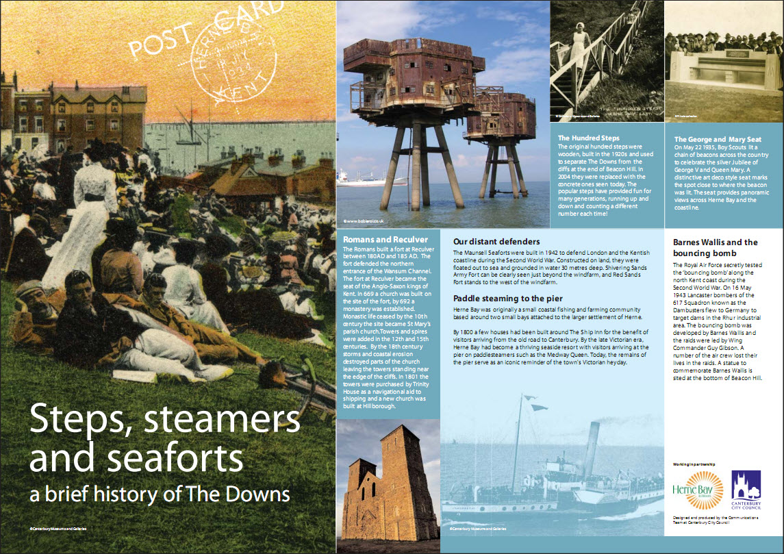
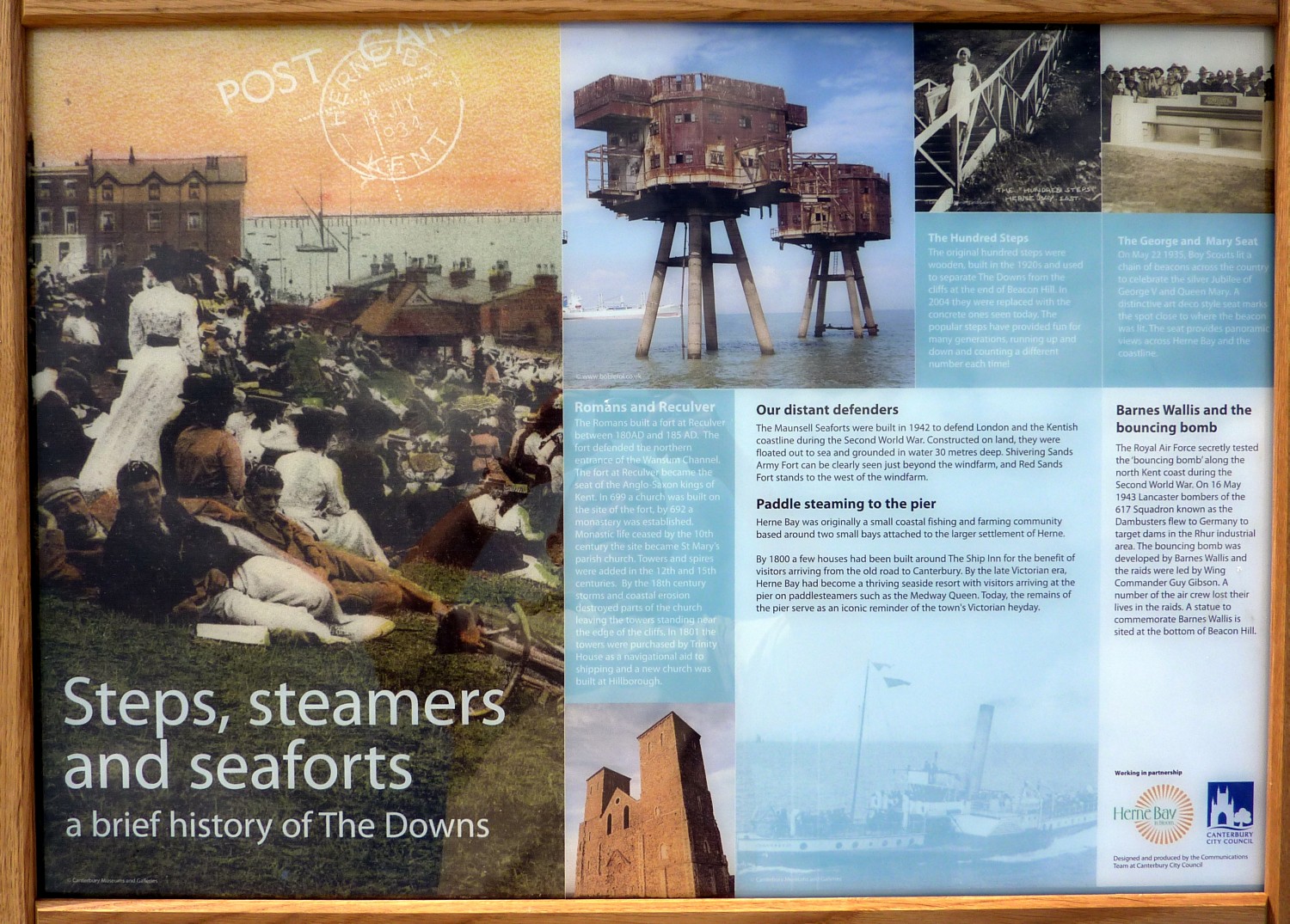
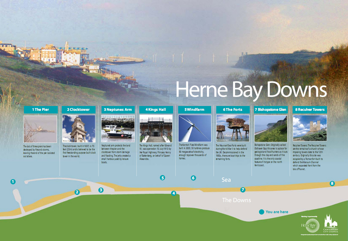
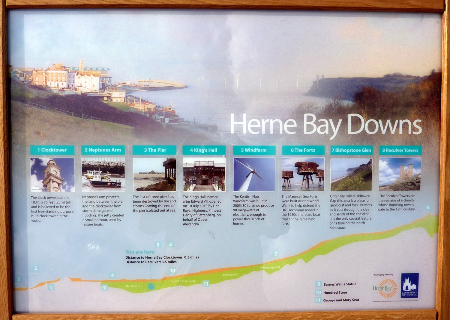
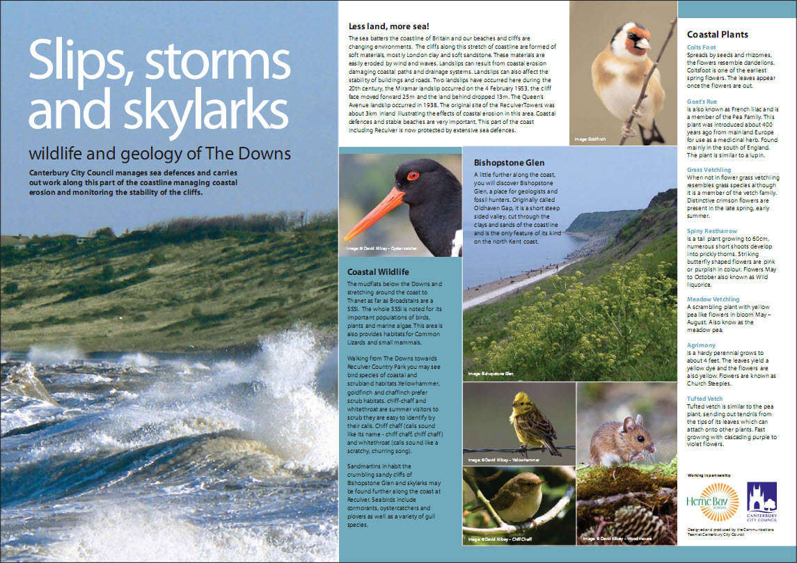
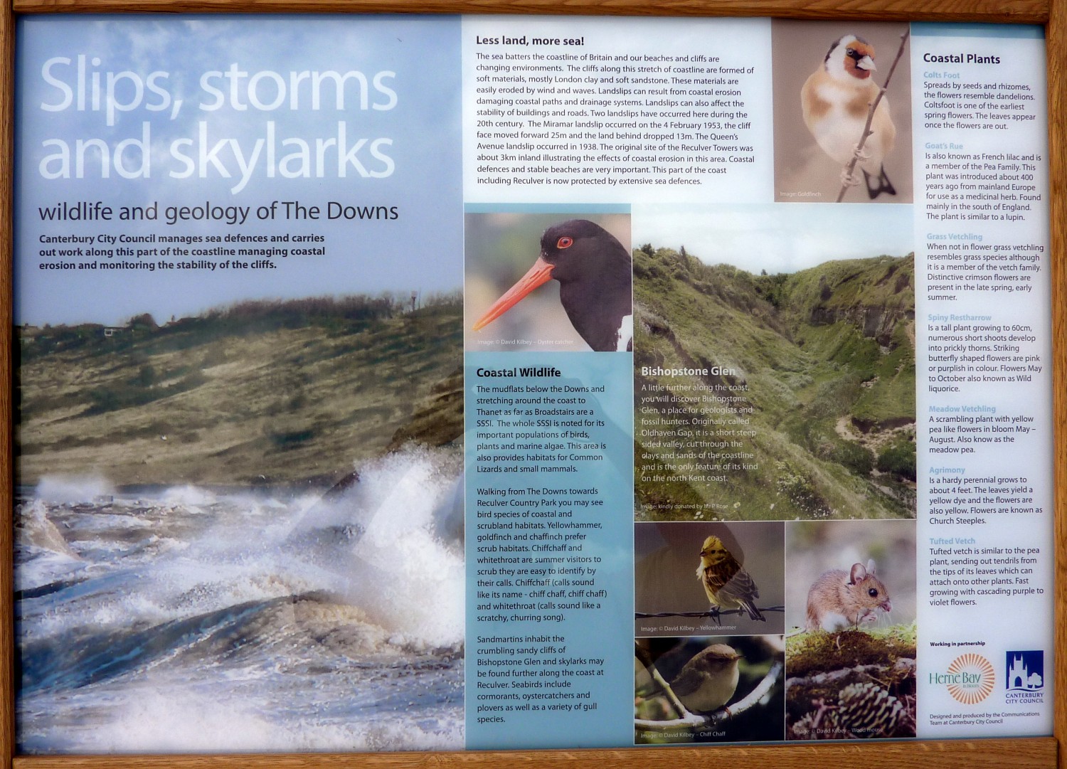
The long-awaited information panels have arrived on the Downs. These have been nearly two years in the making, with the world at large getting a peek in the last couple of months. Here are the "before and after consultation" versions of the panels and below them, for what it's worth, is what I sent the nice people at CCC.

Here's some thoughts on the panels:

Orientation
  • Do not have just one copy of this on The Downs. There should be copies at 1, 3, 4 and 8 - even if only A4 or A3 in the existing noticeboards, to encourage people to come and have a look.
  • I understand what you're trying to do with the background photo, but it could be confusing for visitors.
  • On the map at the bottom, the colours seem to have been reversed: it should be green for The Downs, and grey (or residential splodges) to show where the housing is. At the moment, Herne Bay appears to consist of green fields running up to a concrete strip next to the sea!
  • The map should show the main paths on The Downs and the Promenade, so that people know they can actually get to all the places shown.
  • If the numbered dots on the map aren't going to be arranged to scale (putting Reculver off the right of the map!), they should be in the correct relative positions, i.e. Bishopstone Glen to the right of You Are Here.
  • An indication of the distance, especially to Bishopstone and Reculver, would be helpful.
  • PLEASE increase the size of the text.
  • Space can be reclaimed from the top and bottom of the panel, allowing more height for the 8 text boxes, and the boxes can run wider across the panel. This would allow for the all-important text to be readably large - as it is, it's simply too small, given the space available.
  • (Box 1) I'm sure you can find a better picture of the Pier.
  • (Box 2) The clocktower is 75 feet (23m) TALL. Free-standing is usually hyphenated.
  • (Box 3) In the heading: Neptunes Arm. In the text Neptune's arm. Correctly, both should be: Neptune's Arm.
  • (Box 4) King's Hall has an apostrophe.
  • (Box 7) There's no need to repeat "Bishopstone Glen" in the text.
  • (Box 8) There's no need to repeat "Reculver Towers" in the text.


Wildlife

  • The Downs are seething with nature, and it's hard to know which bits to choose. Personally, I would swap the Chiff-Chaff for a Kestrel - people are more likely to notice a kestrel and wonder what they're looking at.
  • I would like to see the Slow-worm get a look-in - it's an endangered species, we're lucky to have it, and we should be proud of it.
  • Coastal wildlife section: 2nd paragraph "habitats. chiff-chaff" should be "habitats. Chiff-chaff" and in the next sentence chiff-chaff should be hyphenated.
  • Bishopstone Glen: don't just repeat what's appeared on the Orientation Panel - say something additional and wildlife-y about it, like its distinctive insect life.
  • Bishopstone Glen: rather than a picture that doesn't even show the Glen, have a picture looking up (or down) the glen, so people can see what an odd and interesting place it is: attached.
  • The description of the Miramar landslip is confusing.
  • Pictures, or at least line drawings, of the plants mentioned would be much more useful than the very brief descriptions.
  • About one-third of this panel is wasted on pictures of what people can already easily see, just by glancing away from the panel - use it instead for wildlife identification pictures and/or wildlife info.


Heritage

  • I like this - it gives a feel for the range of history in Herne Bay. Easily the best of the three panels.
  • I think the Hundred Steps, George & Mary Seat, and the Barnes Wallis statue should be marked on the Orientation Panel.
  • The Bouncing Bomb section should mention that it was tested just along the coast at Reculver - otherwise it looks like the statue is our only link to the Dambusters.
  • There MUST be a clear message directing people to the Herne Bay Museum (for example in the white space under the bouncing bomb paragraph). I've had an email from Margaret Burns saying that she cannot see any objection to including a reference to the Museum.

Friends of the Downs home page


All original material copyright © 2010-2014 HerneBayMatters.com All rights reserved. All external links disclaimed.