contact us

Use the form on the right to contact us.

You can edit the text in this area, and change where the contact form on the right submits to, by entering edit mode using the modes on the bottom right.​


Herne Bay, England, CT6
United Kingdom

Community website for all things Herne Bay (Kent, UK). Covers: The Downs, Herne Bay Museum, Herne Bay Historical Records Society, Herne Bay Pier Trust, Herne Bay in Bloom, East Cliff Neighbourhood Panel, No Night Flights, Manston Airport, Save Hillborough, Kitewood, WEA, Local Plan and much, much more...

Friends of the Downs

Meeting with CCC at the King's Hall

HBM

[Rosemary Selling was taking proper minutes - this is the condensed version...]

FotD: Cllr Gillian Reuby, Phil Rose, Ros McIntryre, Phil Cheeseman
CCC Outdoor Leisure: Richard Griffiths, Rosemary Selling
CCC Street Scene: Richard Davidson
Kent Wildlife Trust: Fred Booth

1. Richard Griffiths (RG) told us that the Downs Management Plan would now be part of a wider Management Plan for the QE2 Coastal Park. This is unlikely to speed things up.

2. RG said the Plan would be "survey-led", with the Plan being produced when we know what we've got.

3. Fred Booth (FB) pointed out that in parallel with the fieldwork, desk research would also be useful, particularly in well-documented areas like ornithology (check Kent Ornithological Society).

4. FB's Survey will run from April-August, the results are expected in September.

5. The Kent Mammal Group (KMG) would help with a survey from September onwards. The necessary training would be provided at Wildwood.

6. RG expects the Plan to be drafted in late Autumn/Winter 2011, issued for consultation Spring 2012, and signed off Summer 2012.

7. Serco's contract up for renewal in 2013, but is being reviewed currently.

8. In October 2009, there was a pot of £14k of S106 developers' contributions ear-marked for the Downs. The cost of the KWT survey and "signage" leaves us with £10k.

9. Community Payback "volunteers" widely praised for their work weeding the paths and clearing shingle.

10. Litter picking - we now have the necessary sheaf of paperwork to complete before litter-picking. Now we just need to find out what dates our volunteers are available on.

11. The number, location and style of litter bins and dog bins will be discussed at the next PACT/Panel meeting, as will grass cutting and trimming.

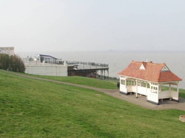
12. Shelter. Although the Victorian shelter was covered by CCC's insurance, it was under-insured. There is a suggestion that the shortfall can be absorbed by rolling it into the QE2 proposal... the Queen's Shelter, perhaps.


My thoughts:

QE2 status is not a foregone conclusion - the process is ill-defined and involves bidding and public voting. CCC display great confidence that it will be awarded, to the point of making progress on the Downs management plan dependent on it. RG emphasised the the management plan should be "survey-led", and this seems to him to be reason enough to put practically everything on hold until the Plan is complete.

The S106 Budget: We knew £2k was allocated to the KWT survey, having agreed to it at the FotD launch meeting in Autumn 2010. RG says £2k has been spent on "signs" - presumably the three new information panels, which were a Herne Bay in Bloom initiative. I'm surprised any of "our" S106 went towards these boards. The fact is that we have no control over the S106 Budget, although we are allowed to bid for funding from it on a project by project basis.

Richard Davidson (of CCC Street Scene) said there wouldn't be any more gang-mowing on the rough Downs this year, as the contract for that area stipulates one cut a year. We would welcome a statement (in writing) to that effect, and a clear understanding that the trimming around the steps (4 times a year) won't be done with tractors that leave wide swathes scalped. Similarly, we would welcome a written assurance that no grubbing, cutting, pruning or trimming of the blackthorn will happen before the Management Plan is complete.

If you have any thoughts on this, or any suggestions for the agenda of our next meeting with CCC, please add a comment below.


Friends of the Downs home page

How people use the Downs

HBM

The Downs is a low profile site from the point of view of marketing.

The evidence questionnaires for the Village Green application demonstrate that over 95% of the people who use the Downs are from Herne Bay. There are no signposts or notice boards to direct visitors to the town towards the Downs. Moreover, the two main areas of visitor parking in the town - the seafront and the off street car parks – are all a good walk from the Downs. The Downs is also a good walk from the train station. Even those visitors who get as far as the King’s Hall, right at the western edge of the Downs, will see no information board to tempt them to walk up the slope and enjoy the full sweep of the Downs.

Informal recreation

We know from the 1,181 evidence questionnaires completed to support the Village Green application that people use the Downs for informal recreation. There are very few flat surfaces on the Downs and so there is no space for full-scale team games that would require a dedicated pitch. Similarly there are no dedicated running or cycle tracks on the land and few hard standing paths across it. The land therefore lends itself best to informal activities such as walking, dog walking, running, cross-country cycling, interval training, watching the sea and the boats, kite flying, painting, photography, foraging, educating children, bird watching, bat watching, drawing, cricket, tobogganing, skiing, family celebrations, picnicking and nature walks.

For the whole town

The Village Green evidence questionnaires tell us that there is a very broad age group uses the Downs – both the very young and the very old use the land. Some of the regular and more elderly users have been using the land since they were brought here as children by their parents. Now, they use it for walking, watching the view, or for playing with their grandchildren. Probably the biggest group of users is the regular dog walkers as this is the only place in the area where a dog can be walked off the lead.

For years

Many users visit the land twice daily. Some, no longer mobile, come as infrequently as once or twice a year when someone else brings them. The 1,181 users have been using the land for an average of 24 years each. This demonstrates great loyalty to this scrubby bit of rather unglamorous but much-loved land.

In completing their evidence questionnaire, many people volunteered additional comments about the future of the land. What they want is clear. They want it to be kept as it is. There is no local mandate here for turning the Downs into a neat and manicured space. It is the semi-natural appearance of the land and the freedom that this gives people to use it as they wish that appeals to the people who use it.


Friends of the Downs home page
The history of the Downs

HBM

Herne Bay is lucky enough to have the Downs because, from 1881 onwards, a series of local people gifted plots of land to the town. About half of the site was gifted to the town in this way. There are long-standing covenants between these benefactors and the Council to keep the Downs as a public open space for the recreation and enjoyment of local people and the wider public forever. The Herne Bay Urban District Council, in receiving these gifts of land on behalf of the town, recognised at the time what a great resource and asset the Downs would be to Herne Bay.

A tithe map of the Downs... fields and not much else!​ (1840)

A tithe map of the Downs... fields and not much else!​ (1840)

The other half of the site has come into the hands of the Council for a number of different reasons. Some plots of land were acquired under the powers of the Coast Protection Act. Others have been acquired on the basis of adverse possession.

It is important to the Friends of the Downs to stay true to the original intentions of the town’s benefactors, and to keep the Downs open for everyone to use for lawful recreation, freely and free of charge, forever.

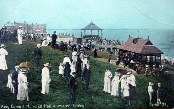
In the town’s Victorian heyday, the Downs was used extensively for that popular pastime – promenading. “A Visitor’s Guide to Herne Bay” published in 1859, has the following description:

“It is a pleasant change from the stroll along the beach to ascend the rising ground at either extremity of the Parade. At the eastern end, you come immediately on The Downs, which though narrow, extend for miles along the coast. Gradually ascending, they form at first an easy slope of greensward, dotted with brakes of furze and heath, and falling away to the level of the beach. Seats planted on the green turf are liberally provided, and no healthier spot can be imagined for exercise and recreation. Here children gambol in freedom an safety in the sea breeze; and after the plunge of bath or bathing machine, of which there are stations just below, nothing can better help to circulate the blood than a bracing walk on The Downs.”
Edwardian postcard​

Edwardian postcard​

 “The New Guide to Herne Bay” published in 1875, describes the Downs as follows:

“The East Cliff, situated beyond the confines of the old town, a parade of an altogether wilder character, is not inappropriately styled “The Down”. Here invalids who cannot make excursions inland may take advantage of the many rustic seats dotted in every direction on these grassy slopes, and enjoy at leisure the exhilarating sea breezes, and the expansive view across the bay below.”

​An undated painting, earlier than 1831, shows a crop of what looks like corn being harvested on the Downs and a story going as far back as 1818 tells of two soldiers from the military signalling station at Herne Bay fighting a duel on the Downs.


Friends of the Downs home page
A sad, bad day

HBM

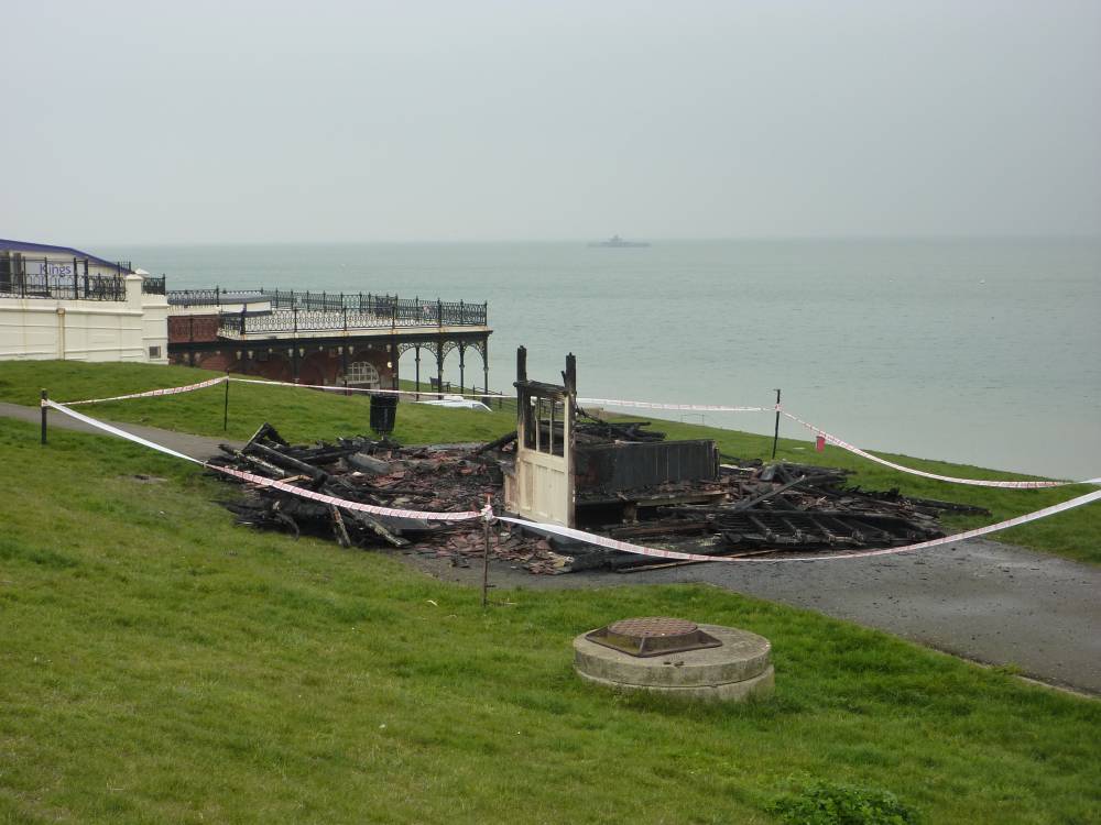
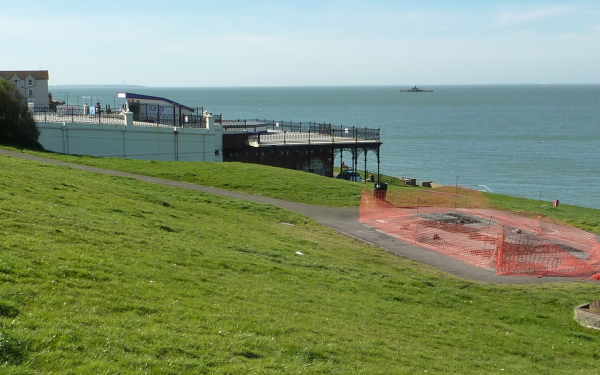
The Victorian shelter by the King's Hall has been burnt down by a scumbag or scumbags unknown.

At the moment, it is unclear whether it was (a) charmless drunken youths, or (b) a local resident wanting to deny the aforementioned youths a meeting place. The CCTV on the HB Sailing Club shows the fire starting at about 2:45am, and going strong by the time the fire brigade arrived.

The shelter was the winner in a Victorian design-a-beach-shelter competition, so with luck the original plans and designs will be available somewhere (Historical Records Society, perhaps?), should anyone feel like restoring/rebuilding it.

Should it be rebuilt? If so, where?


Friends of the Downs home page

Wildlife survey on the Downs

HBM

The Friends of the Downs launch the 2011 Wildlife Survey

2011-03-28-233538.png

The Friends of the Downs and CCC are developing a long-term plan for the Downs, and need to know what wildlife already lives here. The Friends will be working with Kent Wildlife Trust (KWT) and other nature groups to survey the flora and fauna on the Downs over the coming year.

On Wednesday, April 6th at 5pm at the King's Hall, we will be starting the 2011 Survey with a brief presentation and induction from one of KWT's wildlife experts, to show us how the surveying needs to be done.

It doesn't matter whether you use the Downs occasionally, or daily - you will still be able to take part and help us. Places are limited, but if more people are interested than can comfortably fit in one group, we can run another one later. Please contact FriendsOfTheDowns@gmail.com to find out more, and to book your place.


Friends of the Downs home page


All original material copyright © 2010-2014 HerneBayMatters.com All rights reserved. All external links disclaimed.